The Black Belt Nature and Heritage Trail: The Black Belt is named for the rich black soil that grew superior cotton during the 19th century. The collapse of the plantation economy during the Civil War left a legacy of “soul food” cooking, art fashioned from found materials, vast stretches of pristine river bottom land and, most recently, the Civil Rights Movement.
The people of this remarkable remnant of the Old South invite you to explore what you’ve heard about: Tuskegee Institute, the Edmund Pettus Bridge at Selma, Gee’s Bend and the famous quilters, quaint shops in Marion, mansions in Demopolis and Greensboro, and candies made by hand at Priester’s Pecans. The terrain formed by the meanderings of the Black Warrior, Tombigbee and Alabama rivers is home to numerous species of flora, birds and other wildlife. Explore the biologically diverse state parks and other natural habitats. Take your time. Spend several days here. Be transported back to an era that you thought had vanished.

Destinations Near the Byway:
Coleman Center for Arts and Culture
Description: The Coleman Center for Arts and Culture has brought the arts to the Black Belt region since the mid-1980s, holding exhibitions, conducting workshops, and sponsoring local festivals and events. You’ll find the work of both regional and nationally recognized artists here. The Center regularly offers workshops in artistic media ranging from ceramics and photography to drawing and knitting. The Center’s goal is to improve the quality of life in the Black Belt region by nurturing creativity and by revitalizing traditional arts, culture, and community. The Center sponsors Black Belt Designs, a non-profit program that empowers Black Belt residents through production of custom-designed clothing and wearable art. The Coleman Center also provides space for town forums and adjoins the city library. Directions: From I-59/20, take exit 8 and drive 2.7 miles south on AL 17 to York. Turn left on Avenue A and travel one block. From US 80, head north on AL 17 for 3.4 miles. Turn right on Avenue A and travel one block.
Access: Mon-Fri 9-4:30 (closed 12-1);
Sat. 9-12; Free
GPS Coordinates: N 32.48461, W 88.29545
Site Contact: Coleman Center for Arts and Culture 630 Avenue A, York, AL 36925
(205) 392-2005, www.colemanarts.org
includes exhibits, adjoins library
Demopolis Historic District-Gaineswood National Historic Site/Bluff Hall
Description: The Smithsonian Guide to Historic America: The Deep South calls Gaineswood “one of the three or four most interesting houses in America.” Owner-architect Nathan Bryan Whitfield built the mansion over a period of eighteen years, from 1843 to 1861. The State of Alabama acquired Gaineswood in 1966, and the Alabama Historical Commission began extensive restoration. The interior is elaborate, containing many original furnishings and some of the finest plasterwork in any 19th-Century residence in the country. Knowledgeable staff lead tours of the site. While at the mansion, pick up a map of historic downtown Demopolis. In Demopolis, be sure to visit historic Bluff Hall at 405 N. Commissioners Ave. Built in 1832, it was modified in 1850 in Greek Revival style. Today it contains area displays, exhibits, and an excellent gift shop with many locally crafted items. Other historic buildings include the renovated Trinity Episcopal Church at 401 North Main Avenue. Dating from 1869, Trinity’s handsome interior is well worth seeing. Directions: From US 80 in Demopolis, head north on US 43 (Cedar St.) for 0.3 miles. Gaineswood is on the right at 805 S. Cedar.
Access: Tue-Fri 9-4; tours on the hour; Fee
GPS Coordinates: N32.50860, W 87.83518
Site Contact: (334) 289-4846
www.preserveala.org
includes gift shop
Bigbee Bottom Trail and Lower Pool
Description: The largest lake in the Black Warrior-Tombigbee system, Demopolis Lake extends 48 miles upriver on the Black Warrior, 53 miles upriver on the Tombigbee, and covers 10,000 acres. The Bigbee Bottom Trail begins near the Demopolis Site Office and winds down to the parking area for the Lower Pool, traversing a variety of habitats, from pine plantation to hardwood bottomlands and bald cypress sloughs. Oaks, hickories, sweetgum, and ash are among the canopy trees. Palmettos and switch cane are common at ground level. From spring through fall, you’ll find many wildflowers blooming along the trail. Watch for the butterflies that feed on the wildflower nectar, as well as many species of dragonflies. Bring your binoculars, as birdlife abounds here, including permanent residents like Red-shouldered Hawk, Barred Owl, Pileated and Red-bellied Woodpeckers. In spring, watch for returning migrants, including Prothonotary Warblers in the cypress sloughs, Acadian Flycatchers, and Northern Parulas high in the canopy, as well as Hooded Warblers and Kentucky Warblers in the understory. The Lower Pool area offers superb views of the Tombigbee River. Learn more about birding at this Corps of Engineers site here.
Directions: From US 80 in Demopolis on the west side of town, turn north at Maria St. and travel 1.1 miles. Bear left at the fork onto Lock St. continuing 0.5 miles past Foscue Creek Park. Bear right at the fork and travel 0.2 miles, bearing right at a second fork into the entrance to the Demopolis Site Office located 0.3 miles ahead. Visitors can obtain information for the Bigbee Bottom Trail and Lower Pool here, as well as for other recreational areas.
Access: Free, with some fee areas
GPS Coordinates: Demopolis Site Office- N 32.51606, W 87.87435
Site Contact: Demopolis Site Office
384 Resource Management Dr.,
Demopolis, AL 36732-1546
Phone: (334) 289-3540
www.sam.usace.army.mil/op/rec/war-tom/
includes trailer sites, laundry, playgrounds, hunting, rec facilities
Chickasaw State Park
Description: Stretch your legs at Chickasaw State Park, where you’ll find six miles of trails traversing the park’s 520 acres of pine forests and hardwoods. The nature trail is very lightly maintained and a bit of a challenge to find, but your efforts will be well rewarded. Watch for bigleaf magnolia in the understory and catch the fragrance of its huge, ivory flowers in springtime. In fall, its red, cone-shaped fruits ripen, loaded with scarlet seeds that provide food for many songbirds, including Yellow-bellied Sapsuckers, Red-eyed Vireos, Eastern Towhees, and Eastern Kingbirds.
The park also offers campsites, restrooms, a wading pool, grilling pavilion, playground, picnic areas, and dump station. Just across the highway lies a handicapped-accessible, state-operated hunting area. This state park is also part of the Alabama Birding Trail program.
Directions: From US 80 in Demopolis, head south on US 43 for 10.8 miles. The park is on the left, and the handicapped-accessible hunting area is across the highway.
Access: Free
GPS Coordinates: N 32.36266, W 87.77903
Site Contact: 1 (800) ALA-PARK
www.outdooralabama.com
includes playground
Selma
GPS Coordinates: N 32.40603435, W 87.0201596
The Central Loop begins in Selma, a city steeped in Black Belt cultural heritage. As you enter Selma, you are retracing the course of some of the landmark events in our nation’s history. A city that proudly promotes its history, from long before the Civil War Battle of Selma through the turbulent Voting Rights era, and looks towards the completion of the Interpretive Center on the nation’s only dually designated National Historic Trail and All-American Road. In downtown Selma, you’ll find the Edmund Pettus Bridge. On March 7, 1965, this bridge gained international attention when Voting Rights activists began a march from Selma to Montgomery to protest discrimination against African-Americans. When marchers crossed the Edmund Pettus Bridge, they were attacked by state troopers and the sheriff’s posse. Mounted officers rode into the crowd, beating, kicking and tear-gassing the demonstrators. Televised internationally, the events of “Bloody Sunday” spotlighted the depth of racial intolerance. On March 21, under federal protection, marchers again crossed the Pettus Bridge. Five days later they reached Montgomery, where a crowd of 25,000 joined them en route to the state capitol.
GPS coordinates: N 32.40649, W 87.01900
Near the foot of the Edmund Pettus Bridge, at 1012 Water Ave., the National Voting Rights Museum and Institute tells the story of the historic Selma-to- Montgomery marches. Though the museum contains no flashy exhibits, it packs a powerful punch through photographs and memorabilia chronicling the lives of the individuals who led or participated in the marches. The museum sponsors community events, including the annual Bridge Crossing Jubilee held in March of each year to celebrate the struggle to obtain the right to vote.
GPS coordinates: N 32.40616, W 87.01986
Take time to explore the many other heritage sites along Historic Water Avenue. Upon exiting the National Voting Rights Museum, look across to the Harmony Club, a Renaissance Revival structure built as a social club by Selma’s Jewish community in 1909. Next, head left or west to the Bienville Monument, on the bank overlooking the Alabama River where Water Avenue intersects with Lauderdale Street. This monument commemorates D’annville’s mapping of this area in the 1700s. The name “Ecor de Bienville” was changed three additional times, the last being in 1820 when William Rufus King (Alabama’s only US Vice President) named her “Selma,”which means high seat or throne.
GPS coordinates: N 32.40603435, W 87.0201596
Head west towards the Pettus Bridge and you will pass, at the corner, the Selma Times-Journal building which houses the oldest newspaper in Alabama, and exemplifies a typical early 1870s Italianate Victorian storefront. Across this intersection is the site of the anxiously awaited Regional Visitors Information and Interpretive Center for the Selma-to-Montgomery National Historic Trail.
Farther east on Water Ave., lies the St. James Hotel, built in 1837. It is the only existing antebellum riverfront hotel in the southeast and features authentic period furnishings in the common areas and reproductions in the guest rooms. It overlooks historic Water Avenue and the beautiful Alabama River and sits on the location of the original 1885 toll bridge. The curved landing, cornerstone and the bridge tender’s cottage are all that remain.
The Old Depot Museum, on the corner of Water Avenue and Martin Luther King, Jr. Street, was built on the site of the Confederate Naval Foundry, which was destroyed by Federal troops during the Battle of Selma in 1865. It was built in 1891 in the Romanesque Revival style of architecture. The museum building houses exhibits covering more than two hundred years of history in the Selma and Dallas county area, including Native American artifacts. Among the museum’s most valuable collections is the Mary Morgan Keipp photographic collection, which depicts the life of sharecroppers near the end of the 19th century. The Black Heritage wing houses a number of artifacts from the Reconstruction era through the 21st century.
GPS coordinates: N 32.40838, W 87.01380
Unlike so many surviving antebellum buildings, the Vaughan-Smitherman Museum, at 109 Union Street, was never a residence. Built in 1847 as a school, it served since that time as a Confederate hospital, the Dallas County Courthouse, a military institute, public hospital, and civic building. The museum contains a variety of displays that reflect its own fascinating history, as well as that of Selma.
GPS coordinates: N 32.40503, W 87.02568
Located on Dallas Avenue / Hwy 22, Old Live Oak Cemetery, listed on the National Register of Historic places, provides a permanent residence for some of Selma’s most prominent citizens. It includes a memorial circle where more than 155 Confederate soldiers are buried and the Confederate Monument honors many soldiers killed during the Civil War. Alabama’s only US Vice President and founder of Selma, William Rufus King, Alabama’s first African-American congressman, Benjamin S. Turner, US Senators and Abraham Lincoln’s sisters-in-law are shaded by magnificent 140-year-old trees draped with Spanish moss which make the cemetery lovely place for a peaceful walk.
GPS coordinates: N 32.40529, W 87.03136
Sturdivant Hall, at 713 Mabry Street, is one of the finest examples of Neo-Classical Greek Revival architecture in the country. Listed on the National Register of Historic Places, the 6,000- square-foot mansion is stunning, and the furnishings are even more spectacular. In addition to the main building, the preserved outbuildings include smoke house, dry pantry, wine cellar, kitchen (now a gift shop), servant quarters and carriage house. The grounds are magnificent and include formal gardens, as well as a newly developed antique rose garden.
GPS coordinates: N 32.41291, W 87.02847
Founded in 1787 by African-Americans, the Brown Chapel African Methodist Episcopal (AME) Church, at 410 Martin Luther King, Jr. Street, became the organizational base for Voting Rights demonstrations led by Dr. Martin Luther King, Jr., and served as the starting place for the Selma to Montgomery marches of March 1965. A National Historic Landmark, the Chapel remains an active church. The Chapel and its monument to Dr. King can be viewed from outside. The Selma to Montgomery National Historic Trail / All American Road begins at this historic church.
GPS coordinates: N 32.41258, W 87.01551
During the 1960s, Voting Rights organizers used the First Baptist Church, at 709 Martin Luther King, Jr. Street, to gather and disseminate food, clothing, and other supplies to Voting Rights activists. The Reverend Martin Luther King, Jr. frequently spoke here during the height of the Voting Rights movement. Erected in 1894, the building was restored following storm damage, and was rededicated in 1982. A national historic site, it is the starting point for the Martin Luther King, Jr. Street Historic Tour.
GPS coordinates: N 32.41480, W 87.01803
From the First Baptist Church, walk south to follow the Martin Luther King, Jr. Street Historic Walking Tour. In early 1965, Selma was the site of vigorous efforts to overcome the many obstacles facing African-Americans as they attempted to register to vote. Though protesters faced threats, beatings, arrests, and even murder, their perseverance helped secure passage of the Voting Rights Act of 1965. The self-guiding walking tour passes the George Washington Carver Homes, the historic Brown Chapel AME Church, and twenty memorials that tell the story of Selma’s Voting Rights struggle.
GPS coordinates: N 32.41480, W 87.01803
Old Cahawba Archaeological Park
Description: For thousands of years, Native Americans inhabited this area at the confluence of the Cahaba River and the Alabama River. Following the defeat and expulsion of the Creek Nation in 1814, settlers from Virginia, Georgia, and the Carolinas swarmed into the area. Old Cahawba became Alabama’s first capital in 1820. Though the capital was moved to Tuscaloosa just five years later, Old Cahawba continued to prosper as a result of the cotton boom. Following the Civil War, Cahawba declined dramatically and by the end of the 19th century, most of the buildings were in ruin. During the 1900s, nature reclaimed much of the site, and the Alabama Historical Commmission is taking steps to preserve and interpret the site.
Today, the lure of this ghost town—its moss covered trees, Native American artifacts, abandoned streets, flora, artesian wells, imposing brick ruins, and cemeteries—draws many visitors. The welcome center offers interpretive exhibits of Native American artifacts and memorabilia from the town’s settlement heyday. Follow the self-guided nature trail through Old Cahawba’s town commons, and explore the bluffs overlooking the Alabama River.
Directions: From Selma at the intersection of US 80 and AL 22, head west on AL 22 for 8.6 miles. Turn left on CR 9 and travel 3.3 miles to the stop sign. Turn left on CR 2 and travel approximately 1 mile to the visitor center.
Access: Park daily 9-5, welcome center daily 12-5; Donation appreciated
GPS Coordinates: N 32.31963, W 87.10463
Site Contact: Old Cahawba Park, 9518 Cahaba Rd., Orrville, AL 36767
(334) 872-8058, www.cahawba.com
includes exhibits, interpretive materials, and self-guided nature trail
Also part of the Alabama Birding Trails Black Belt Birding Trail: http://www.alabamabirdingtrails.com/sites/old-cahawba/
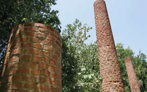
Kenan’s Mill
Description: Built in the 1861 as a waterpowered turbine gristmill, Kenan’s Mill produced water, ground cornmeal, and grits until 1968. A concrete dam, added in 1904, creates a scenic waterfall, and a swinging bridge spans the creek. On the grounds you’ll also find a fascinating 19th century brick charcoal kiln. Owned by the Kenan family since its construction, the mill was restored in 1987 by Wallace and Elizabeth Kenan Buchanan who donated it to the Selma-Dallas County Historic Preservation Society in 1997. The Historic Society hosts special events at the site, including Kenan’s Mill Fall Festival and Bluegrass Event. Though the mill is currently open for visitation only during such events or by special arrangement, this may change in the future. Contact the Selma Dallas County Historic Preservation Society for information on visiting (you can obtain their current contact information from the Dallas County Chamber of Commerce, listed below).
Directions: Directions obtained by phone when permission to visit is obtained.
Access: Restricted, currently available only by special arrangement or during public events
GPS Coordinates: N 32.45196, W 087.03416
Site Contact: Dallas County Chamber of Commerce
1 (800) 45-SELMA or (334) 875-7241
Black Belt Research and Extension Center
Description: The Black Belt Research and Extension Center was originally established in 1929 and began operation in 1930 as one of the five original sub-stations of the main Alabama Agricultural Experiment Station at Auburn University. The 1116-acre facility has long been recognized as one of the top beef and forage research centers in the United States.
The Black Belt Research and Extension Center is the site of the first documented cases of fescue toxicity in cattle. Subsequent research has led to identification of management practices that help producers better manage fungus-infected pastures. Long-running projects in crossbreeding and genetic improvement are also recognized nationally for their contributions to the overall improvement of beef production in the United States. Note: For safety reasons, the Center asks that visitors do not interact with the cattle.
Directions: From Selma, Alabama, at the intersection of AL 14 and US 80, travel west 9.2 miles to the intersection of US 80 and CR 45. Travel north 2 miles on CR 45, to the Black Belt Research and Extension Center entrance on the left (CR 58).
Site Access: Mon-Fri, 8-4
GPS Coordinates: N 32.281674 W 87.135224
Site Contact: Black Belt Research and Extension
Center, 60 Dallas County Road, Marion
Junction, AL, (334) 872-7878
http://www.ag.auburn.edu/aaes/outlyingunits/blackbelt.html
Paul M. Grist State Park
Description: This tranquil 1,080-acre park includes a 100-acre lake, where you can rent a canoe or small boat for fishing or exploring. Several miles of hiking trails wind through woodlands of oaks, sweetgum, sweetbay magnolia, yaupon, American holly, and American beech. Bring your binoculars and watch for such summer residents as Yellow-billed Cuckoo, Eastern Wood-Pewee, Great-crested and Acadian Flycatchers, Red-eyed and Yellow-throated Vireos, Wood Thrush, Northern Parula, American Redstart, Hooded and Kentucky Warblers, and Summer Tanager. At night, listen for Chuck-will’s-widow, Barred Owl and Eastern Screech-Owl. Open areas around the lake attract swallows and Eastern Kingbirds, as well as scores of butterflies and dragonflies.
The park provides both primitive campsites and sites with full hookups, as well as picnic areas, showers, playground, beach and swimming area.
Directions: From the Selma intersection of US 80, head northeast on AL 22 for 11.1 miles. Turn left onto CR 222 and travel 1.7 miles. Turn right on CR 37 and travel 1.1 miles to the entrance road on the right.
Access: Daily; Fee
GPS Coordinates: N 32.59088, W 086.99993
Site Contact: Paul M. Grist State Park,
1546 Grist Rd., Selma, AL 36701
1 (800) ALA-PARK or (334) 872-5846
includes showers, interpretive markers
http://www.alabamabirdingtrails.com/sites/paul-m-grist-state-park/
Lowndesboro Historic District
Description: Lowndesboro offers a treasure trove for architecture and history buffs, with a remarkable array of domestic architecture, from simple early cottages to grand columned houses. Lowndesboro was settled before 1820 by planters from South Carolina. Originally named McGill’s Hill, residents changed its name to Lowndesboro in 1832, in honor of statesman William Lowndes.
Take time to explore Lowndesboro’s many historic buildings. Along CR 29, you will discover some beautiful churches, including the St. Paul’s Episcopal Church, built in 1857. North of St. Paul’s lies the Lowndesboro United Methodist Church, built in the 1880s. Further along is the Lowndesboro Presbyterian Church, erected in 1850, and the Lowndesboro Baptist Church, dating from 1888. The former CME Church, built in 1830, is surmounted by the dome from the first state capitol building at Cahawba, now a ghost town on the banks of the Alabama and Cahaba Rivers (site 26). Many of these historic churches are in active use, so visitors should conduct themselves accordingly.
Directions: From US 80, approximately 24 miles east of Selma head north on CR 29. The first church is approximately 1.1 miles and the others can be found by continuing further north for less than a mile.
Access: Free
GPS coordinates: N 32.27816, W 86.61120
Site Contact: Lowndesboro Heritage Association
(334) 278-3413
Amenities: small town amenities
Holy Ground Battlefield Park
Description: Once a major town of the Creek Nation, this site was sacred to the Creek people. In 1813, war with the United States ensued, and on December 23, U.S. forces and Choctaw allies under the command of General Claiborne attacked. After most of the Creeks escaped across the river, General Claiborne’s men burned the town. Three months later, General Andrew Jackson defeated the Creeks at Horseshoe Bend, thus ending the Creek Indian War of 1813-1814. Subsequently, the Creeks in this area were exiled to Oklahoma.
This site offers much, including excellent overlooks of the river, interpretive displays, and a nature trail. The hardwood bluff forest include white and swamp chestnut oak, shagbark and nutmeg hickory, black cherry, southern sugar maple, white ash, winged elm, flowering dogwood, and tuliptree (tulip poplar). The diversity provides habitat for numerous birds and mammals, from armadillos and beavers to Red-shouldered Hawks and Yellow-Billed Cuckoos. Keep an eye on the river for patrolling Bald Eagles and Ospreys. (read more about birding the Holy Ground Battlefield Park here)
Directions: From Montgomery, take I-65 south to exit 167. Turn right and head west on US 80 for approximately 24 miles to CR 23. Turn right and head north on CR 23 for 4.2 miles. Turn right onto CR 40 for 1.3 miles to the sign, then left for 1.5 miles.
Access: Free with some fee areas
GPS Coordinates: N 32.34828, W 86.68680
Site Contact: U.S. Army Corps of Engineers,
8493 US Hwy. 80 West, Hayneville, AL 36040, (334) 872-9554
http://al-lakes.sam.usace.army.mil
includes interpretive materials, overlooks
Montgomery
Alabama’s Capital City has the distinction of being the “Cradle of the Confederacy” as well as the “Birthplace of Civil Rights.” Since 1817, Alabama has had five capitals. The territorial capital was Saint Stephens, located in southwest Alabama. This served as the temporary seat of government, hosting two sessions of the territorial legislature. In accordance with the enabling act for statehood, the first Constitutional Convention assembled in the North Alabama town of Huntsville in 1819, where the first session of the General Assembly was held in the same year. Cahawba was chosen by the territorial legislature as the temporary capital, with the 1825-26 legislature deciding on Tuscaloosa as the new capital.
As Alabama’s population grew in the state’s more eastern counties, it was decided that the capital needed to be more centrally located. Montgomery was chosen, and a building was completed on “Goat Hill” and presented to the state on December 6, 1847. This building was destroyed by fire near the beginning of the General Assembly’s second session in Montgomery on December 14, 1849. The legislature appropriated $60,000 in February 1850 to build the central section of the present building, which was erected upon the foundations of the original. Architect Barachias Holt designed the new structure.
Visitors will find the star marking the spot where Jefferson Davis was inaugurated as the President of the Confederate States of America in 1861, as well as many monuments on the grounds.
The 1965 Selma-to-Montgomery Voting Rights March ended at the steps of the Capitol, with some 25,000 marchers and out-of-state supporters filling Dexter Avenue. The throng stretched to Dr. King’s former church. “Segregation is on its death bed,” King told the crowd.
Guided tours of the State Capitol are available. Open Monday – Saturday. (334) 242-3935
The First White House of the Confederacy is across the street to the south. This 1835 Italianate-style house was the home of President and Mrs. Jefferson Davis while Montgomery served as the Confederacy’s capital. Many cabinet meetings were held here. First Lady Varina Howell Davis, a Natchez belle, was admired for her hospitality and political savvy. The home displays period pieces from the era and family heirlooms.
At the Archives and History building, find artifacts dating back to the prehistoric peoples of Alabama, as well as items used by pioneer settlers, Civil War era uniforms and flags, and various other displays of important documents that shaped Alabama.
Visitors to Old Alabama Town can see how Alabamaians lived in the 19th and early 20th centuries. Among the historic structures are Lucas Tavern, Grange Hall, a doctor’s office, church, schoolhouse, and corner grocery, along with several beautiful homes from the era. 301 Columbus Street. (334) 240-4500. Admission Charged. Open Mon-Sat.
Lillie Williams moved her family to Montgomery in 1937 where she operated a succession of downtown boarding houses. While living in Montgomery, her son Hiram renamed himself “Hank” and by age 14 was singing on WSFA radio. As they say, the rest is history, and much of that history took place in Montgomery.
The Hank Williams Museum is the best place to begin a visit to Hank’s beloved hometown. The largest collection of Hank Williams clothing, records, paintings and personal items – many on loan from son Randall Hank Williams, Jr. – can be found here. More than a dozen of his famous handmade Nudie suits, as well as hats and boots, are on display. 118 Commerce Street, (334) 262-3600. Admission charged. Open daily.
After viewing items from Hank’s life and career, travel a few blocks to the Oakwood Cemetery Annex and pay respects at Hank and wife Audrey’s final resting place. This site is visited by people from all over the world.
Stop in and enjoy a hotdog and a cold drink at Hank’s favorite Montgomery eatery, Chris’ Hotdogs. Family-owned since 1917, Chris’ still serves hungry diners at 138 Dexter Avenue.
Shortly after marrying his college sweetheart in Marion, Alabama, 24-year-old Martin Luther King, Jr. preached his first sermon at Dexter Avenue Baptist Church, a block from the Alabama State Capitol where Southern secessionists had formed the Confederacy in 1861.
Dexter Avenue King Memorial Baptist Church is a National Historic Landmark because of its status as the birthplace of the Civil Rights Movement. It is the only church where Martin Luther King Jr. served as senior pastor.
Enter through the ground-level doors to the basement where Rev. David Abernathy, NAACP activist E.D. Nixon, King and others vowed a bus boycott following the arrest of Mrs. Parks. King’s predecessor, Dr. Vernon Johns, had long advocated such action. 454 Dexter Avenue, a block west of the State Capitol. (334) 263-3970. Admission charged. Tours are Monday through Friday, walk-through Saturday. Check hours in advance. Groups schedule at least a week ahead of visit. www.dexterkingmemorial.org
Dr. Martin and Mrs. Coretta Scott King lived in the Dexter church parsonage a few blocks southeast of the church from September 1, 1954, until late 1959 when they moved to Atlanta. Mrs. King and their baby, Yolanda, were home when a bomb damaged the front porch one night during the boycott. The minister quickly arrived and quelled angry neighbors demanding revenge.
The Interpretive Center next door offers a short video presentation prior to tours of the parsonage. The house is furnished with period furniture, some dating from the residency of the Kings. A photo of Gandhi in the study recalls the famed pacifist whose teachings were an inspiration to King. 303 S. Jackson Street south of Monroe Avenue. (334) 261-3270. Admission (discount with Dexter Avenue King Memorial ticket). Tours by appointment. www.dakmf.org
Multi-media presentations, period photography and several dioramas bring to life the story of Rosa Parks and the Montgomery Bus Boycott. A vintage municipal bus — used in the movie The Long Walk Home — is used to reenact the arrest of the respected Negro community leader. Visitors can have their photographs made while seated next to a life-size bronze sculpture of the “Mother of the Civil Rights Movement.”
The Civil Rights Memorial designed by international artist Maya Lin is a block south of the church where Martin Luther King was pastor. It honors 40 individuals who died between 1954 and 1968 and encourages visitors to reflect on the struggle for equality.
After you read the names of the martyrs and a timeline of landmark events etched on its black granite table, walk up the entrance at mid-block to enter the new Civil Rights Memorial Center and learn stories of the martyrs.
The “Here I Stand” exhibits chronicle important events that occured downtown during the Civil Rights Movement. A short film in the 60-seat auditorium provides an overview of the movement. Visitors can sign a pledge to work for justice at the Wall of Tolerance. 400 Washington Avenue at South Hull Street. (334) 956-8200. Admission charged.
Tuskegee Institute National Historic Site: Carver Museum
Description: Tuskegee Institute National Historic Site is inextricably bound to the history of two illustrious men: Booker T. Washington and George Washington Carver. Both born into slavery, each achieved personal successes and left legacies that were almost unimaginable for African-Americans in the 19th and early 20th centuries. In 1881, Washington founded the Tuskegee Institute to educate African-Americans as teachers and to help students develop occupational skills. The Institute promoted sustainable farming practices and developed outreach educational programs for tenant farmers.
Carver, the Institute’s most celebrated professor, conducted research that reinvigorated southern agriculture. The George Washington Carver Museum celebrates Carver’s life through photographs, artifacts, and audiovisual programs.
Directions: From I-85, take exit 32 southeast onto CR 51/30 for 1.3 miles. Turn left onto CR 30/Franklin Rd. and travel 4.0 miles to Old Montgomery Rd. The Tuskegee Institute National Historic Site Headquarters is located immediately on the left. Alternatively, take I-85 exit 38 and travel south on AL 81 to Old Montgomery Rd. Turn right and go to the second stoplight. Turn right and follow signs.
Access: Call Carver Museum for tour reservations, (334) 727-3200
Donations appreciated
GPS Coordinates: N 32.42855, W 085.70938
Site Contact: Tuskegee Institute National Historic Site
1212 W. Montgomery Rd.
Tuskegee, AL 36088
(334) 727-6390
includes gift shop and guided tours
Tuskegee Airmen National Historic Site
Description: The Visitor Center interprets the story of the Tuskegee Airmen, the first African- American airmen in the United States military. The story begins in 1939 when the U.S. government offered African-American men flight training through the Civilian Pilot Training (CPT) Act. Tuskegee Institute was chosen as a training site for its commitment to aeronautical training, its engineering and technical instructors, and its climate. In July 1941, just before the U.S. entered World War II, the first cadets reported to Tuskegee Institute to begin training as pilot candidates. The term “Tuskegee Airmen” refers to all who were involved in the “Tuskegee Experience,” including 992 pilots and more than 10,000 additional personnel, including navigators, bombardiers, and maintenance and support staff. The Tuskegee Airmen had to battle not only the enemy overseas but also the racist attitudes of a largely segregated society in the United States. In 1998, President Clinton approved the public law establishing the Tuskegee Airmen National Historic Site at Moton Field.
Directions: From the Tuskegee Institute National Historic Site, head east approximately 0.8 miles to a “T”. Turn left and travel 0.1 miles. Turn right (near Burger King) on AL 81 and head north 2.3 miles. Turn right at the sign for Tuskegee Airmen and Moton Field. The entrance is 0.4 miles on the left. Alternatively, from I-85 take exit 38 south onto AL 81 and follow the signs.
Access: Daily 9-4:30; Free
GPS Coordinates: N 32.45668, W 085.68296
Site Contact: Tuskegee Airmen National Historic Site
1616 Chappie James Ave.
Tuskegee, AL 36083, (334) 724-0922
Bartram Trail: Tuskegee National Forest
Description: Named for William Bartram—famed explorer, writer, artist, and naturalist—the Bartram National Recreation Trail system is composed of segments of trails in Alabama, Georgia, and North Carolina that retrace sections of Bartram’s famed 2,400-mile trek through the Southeast. Here in Tuskegee National Forest, the trail stretches 8.5 miles, with several trailheads along the way.
In upland pine forests, watch for Brown-headed Nuthatches and Pine Warblers. Common woodland residents include Red-shouldered Hawk, Red-bellied, Downy, and Pileated Woodpeckers, Carolina Wren and Carolina Chickadee, Blue-gray Gnatcatcher, and Chipping Sparrow.
Directions: From Montgomery take I-85 east to exit 42. Turn right and travel south on AL 186 approximately 1.2 miles. Turn onto FS 900 and the first trailhead is to the right less than 0.1 miles. Continue south on AL 186 for 0.5 miles to FS 949. Turn left and travel approximately 0.2 miles to the Forest Service headquarters and the second trailhead. For the third trailhead on US 29, return to AL 186 and continue south to the intersection with US 29; turn left and travel 0.8 miles to the trailhead on the left.
Access: Visitor center Mon-Fri 7:30-4; Free
GPS Coordinates: FS 900 trailhead: N 32.47786, W 85.61847
FS 949 trailhead: N 32.47960, W 85.61064;
US 29 trailhead: N 32.47826, W 85.56371
Site Contact: US Forest Service
125 Nat’l Forest Rd. 949,
Tuskegee, AL 36083
(334) 727-2652,
www.southernregion.fs.fed.us/alabama
Learn more about Alabama’s Black Belt Region from the Alabama’s Front Porches website.